Wales Coast Path: Cemaes to Amlwch

WCP Cemaes to Amlwch-2

View to Porth Padrig

13th August 2017 – 14.5 miles

Today was a circular walk – we didn’t even think about buses on a Sunday! – so we decided to start and finish in Cemaes, being a rather prettier spot to return to then Amlwch (sorry, Amlwch).

We paid to stay in the car park down by the beach where we were given what is claimed to be ‘the biggest parking ticket in the world’ and noticed that Cemaes, like Moelfre yesterday, was having a Lifeboat Day. We didn’t detour into the village to see it, but we heard the drum group. We wondered if they were the group from Liverpool – they certainly looked and sounded very similar.

WCP Cemaes to Amlwch

Cemaes

The path skirted the bay, with views across to Wylfa Power Station as we gained height. We stopped for a break at Llanbadrig Point and realised we had not come very far and it might be slow going today! Soon after this we came upon Llanbadrig (St Patrick’s) Church, perched on the cliff top, which is meant to date from the 5th century.

WCP Cemaes to Amlwch-3

Llanbadrig church

The coastline from here was very rugged, on high cliffs with clear views across to the Skerries. There were also quite a few ups and downs over the headlands and into bays. The first major bay was Llanlleiana, with industrial remains and a chimney. I assumed this had something to do with the copper industry but it turns out to have been porcelain works.

WCP Cemaes to Amlwch-5

Llanlleiana porcelain works

We chatted a while to another walker who told us that the next headland was the most northerly point in Wales, so we continued there for our lunch. There is a small, rocky islet, Middle Mouse, which is a bit further north but this is the furthest north you can get without a boat! There were views across to the Isle of Man on the horizon. The headland had a strange structure which we thought was a WW2 lookout post but turns out to have been built to commemorate the coronation of Edward VII in 1902. I’m surprised it is in such a poor state of repair.

WCP Cemaes to Amlwch-6

The northernmost point of Wales

At this point, the battery in my camera gave up …

The bay at Porth Wen also had some impressive industrial archaeology, this time the remains of brick works. A few people had come to the bay on boats and were diving into the harbour.

After this, the path got easier and less rugged. A wide, level path through heather led to Bull Bay – we sat down for a drink in field of black bulls – or maybe they were cows, I didn’t look – and were very glad to see Amlwch in the near distance. I was very tired with feet like lead. Unfortunately, it didn’t seem to get much closer for a while and even when we were almost there, the coast path veered off hugging the coastline, for which, I suppose, we should be grateful!

We returned to Cemaes by the A-road to Bull Bay (that was quick and easy!), then the Coast Path to Porth Wen, and finally along a lane into Cemaes only to find that the chippy is shut on a Sunday – and I had so been looking forward to eating fish and chips looking out to sea. Never mind, we had fish and chips in the hotel restaurant before heading back home. The return journey had taken us half the time of the outward and felt a lot less tiring.WCP Cemaes to Amlwch


Wales Coast Path: Bangor to Caernarfon

WCP Bangor to Caernarfon4th August 2017 – 11.8 miles

I’m not really sure why we haven’t done much of our longer walks in spring or early summer, but here we are again. The forecast looked better today than it has been for a while, and Friday is a better day than Saturday to drive into North Wales in August!

We found a parking place in a semi-residential area above the suspension bridge, then walked down to the bridge, only to find there were several convenient places we could have parked down there!

We soon came across a Botanic Garden. The path lead along the coast, through the trees, including this impressive Lucombe Oak.

WCP Bangor to Caernarfon-2

Lucombe Oak

It was a very pleasant walk, with glimpses of the Menai Strait and the Britannia Bridge, though it was obscured by trees preventing a good photograph. Just past the Britannia Bridge, we found this section which we later learned is a section of the old bridge which was damaged by fire in the 70s.

WCP Bangor to Caernarfon-4

Section of the old Britannia Bridge

The next section was through National Trust woodland in Glan Faenol, where we came across this impressive (and slightly spooky) mausoleum.

WCP Bangor to Caernarfon-5

Vaynol Mausoleum

Leaving the woods, we had lunch in a field with views across the Menai Strait to Plas Newydd on Anglesey.

WCP Bangor to Caernarfon-6

View to Plas Newydd

The route then took us inland along an A-road. There were few waymarks here so it was good to find some at the junction taking us onto a cycle path. We walked this section with a local lady. She told us how she had joined Slimming World and begun to walk every day. She has since lost 5 stone and stopped taking tablets for various medical conditions. She took a fork in the path to head down towards the coast and return to Bangor while we carried straight on. We later found we should have followed her, but we walked along the main road in Y Felinheli until we met up again with the path.

WCP Bangor to Caernarfon-8

Old station building

From here, the Wales Coast Path and the cycle path are part of the Lôn Las Menai which is easy to follow, although a few Coast Path waymarkers would be nice. It was pleasant and easy walking, although again trees prevented us from getting a clear view of the sea.

WCP Bangor to Caernarfon-9

Lôn Las Menai

We followed the path into Caernarfon and round to the far side of the castle.

WCP Bangor to Caernarfon-11

Caernarfon

We crossed the river, so we can park there to begin the next leg of the walk, then took the bus back to Bangor, very close to where we had parked. WCP Bangor to Caernarfon

Wales Coast Path: Aberdaron to Penllech

wcp-aberdaron-penllech19 November 2016 – 15.4 miles

We stayed at a very nice B&B in the centre of the Llyn Peninsula. The owner was chatting to us and said they had a lot of walkers staying there, including another Ruth, who was also walking the Coast Path – yes, I follow her blog! (coastalwalker.co.uk). He very kindly also followed us as we dropped off our car from the turn around point, then drove us down to Aberdaron, so we could do a linear walk. wcp-aberdaron-penllech-2

We had a quick look at the beach and bay at Aberdaron, then set of along the cliff paths. At the next bay we saw a man heading for a dip in the sea! Now, it was a pleasant day for November … but …! wcp-aberdaron-penllech-3

We headed west along the coast, with the bulk of Bardsey Island ahead of us. We climbed over the headland to reach the tip of the Llyn Peninsula, and you could see some of the buildings on the far side of the island. wcp-aberdaron-penllech-4

The coastline became more rugged, with cliffs and jagged rocks facing the Irish Sea. From the high point of the headland, you could see for miles around the coast, up towards Anglesey, south across Cardigan Bay, and inland to the snow-capped peaks in Snowdonia. There was a small coastguard lookout here and there had been an RAF station there during the War – some concrete foundations were visible around the area. wcp-aberdaron-penllech-7

We met a couple of groups of people by the headland. Later we met a runner and a couple of dog walkers, but otherwise it was fairly quiet. There were still a few people around when we reached the wide sandy beach at Porth Oer, families, well wrapped up and kids in wellies. Time was getting on and so we decided to play safe and take the waymarked path on top of the cliff, rather than walking along the beach and finding out why it was called Whistling Sands, just in case there wasn’t an obvious route off the beach at the far end (there was!). wcp-aberdaron-penllech-9

We were conscious of the time, and the light fading. I think this section had a lot of wishful thinking – that bay ahead of us is the one we are heading for! – but it wasn’t. The path was still pretty good, and we could see where we were going, but we knew this would not last for much longer, and so decided to head inland. wcp-aberdaron-penllech-10There were not many signposts, but we headed across a field that looked like a used path heading to a group of houses . At the far end there was a waymarker. We got to the house, walked the short distance across their back garden (sorry! – didn’t set off any alarms or anything!) and to a long farm track back to the road.

By this time, it was almost dark so it was quite a relief to just walk the last mile or two on quiet roads back to the car park. The route actually turned out to be a bit further than we’d anticipated (closer to 16 than 13 miles!) and maybe if we’d checked properly we would have walked a little faster in the morning. Another adventure!wcp-aberdaron-penllech


Wales Coast Path: Aberdaron to Rhiw

wcp-aberdaron-rhiw-420 November 2016 – 11.14 miles

We left our nice B&B, turning down the offer of a lift for a linear walk so that we had the option of lengthening or shortening the walk as we felt like it! We parked again at Aberdaron, heading slightly inland up a small river valley and through fields. wcp-aberdaron-rhiwWe did head down to a caravan site before realising it didn’t look right. Further back up the track there was a waymarker, more easily visible when you were going the ‘wrong’ way! wcp-aberdaron-rhiw-2

This took us back towards the coast, over rolling hills high above the sea. It was another beautiful day, sunny and clear, and fairly warm for November. We looked across Cardigan Bay, taking a bearing and decided that we actually could see Pembrokeshire on the horizon! There were a few sheep grazing and a number of ponies.wcp-aberdaron-rhiw-3

We headed inland up a lovely valley with a stream and waterfalls, and the remains of old mining industry.wcp-aberdaron-rhiw-5

The path then headed back to the coast on open access moorland, again high rolling hills. It appears that the path has been diverted and improved to run closer to the coast than it does on our map, although it has been pretty well waymarked. wcp-aberdaron-rhiw-6

We reached a minor road, close to the National Trust property of Plas-yn-Rhiw and at the western end of Hell’s Mouth Bay, and decided to make that our turnaround point. wcp-aberdaron-rhiw-7

We followed the quiet minor road back to Aberdaron, reaching it just as the sun was beginning to set. wcp-aberdaron-rhiw-8wcp-aberdaron-rhiw

Wales Coast Path: Beaumaris to Mariandyrys

wcp-beaumaris-824 August 2016 – 9.8 miles

Another lovely day. We packed up the tent and left the car at the campsite, then walked down to the coast. We had walked back to the campsite along the Coast Path on-road route last night; this morning we did it again, but along the shore. The tide was well out, but some of the shore was rocky, some parts were muddy, but there were lovely views across to Snowdonia, and Puffin Island coming into view at the corner of Anglesey. We saw a few boat trips from Beaumaris heading out that way. wcp-beaumaris-2

We then moved inland at a small car park where a river came down to the sea. I’m sure I saw a flash of a kingfisher here!

We had a rest on a dangerous bench.wcp-beaumaris-3

wcp-beaumaris-4The route was now mostly along the road, although it was fairly quiet. We passed some old works – presumably from the quarry a little further inland – then arrived at Penmon Priory. We took a little time to look round the priory ruins, the church and the dovecote before continuing along the toll-road.

Penmon point was quite busy. It is such a familiar view from photographs, but neither of us had ever been here before. There was a little excitement – I think someone had decided to swim out to the lighthouse, and had got into difficulties. People on the shore began to shout and wave at a passing yacht to get help, but soon dismissed it shouting “It’s okay. He’s alright now!”wcp-beaumaris-7

We met very few people once we headed away from this point. The route heads away from the coast, but still gave views back towards Puffin Island for a while. We then headed through farm paths and lanes, until we reached a small junction near Mariandyrys which seemed a convenient point to stop.

wcp-beaumaris

From here it was a straightforward couple of miles back to the campsite.wcp-beaumaris-to-mariandyrys


Wales Coast Path: Tal-y-bont to Beaumaris

wcp-bangor23rd August 2016 – 4.9 and 8.2 miles

A walk of two halves.

We camped (in our new tent, following our Shetland adventures) near Beaumaris. We took a morning bus into the centre of Bangor then walked to the pier where we took up the coast path. Always the hardest bit of navigating, finding your way out of a town centre!

The route out of Bangor started on a disused railway line, through shady woods. We saw hardly anybody, despite it being a pleasant, easy path on a sunny August day! I think the line had been used to take slate to the harbour.wcp-bangor-2

At the end, there was a short walk along a road, then a sign, which we nearly missed, lead us across a field then onto an ‘estate’ of new roads but with no buildings whatsoever! It looked like it was earmarked for business or light industry but there was nothing there except the road. Very odd. It was popular with a group of skate boarders though. wcp-bangor-3

We were quite glad to get to the end as it just didn’t feel right. On the map this is shown as an alternative route and it does stop you from having to walk along the road as on the original route. Another mile or so took us past the village of Tay-y-bont and onto the main road where we caught the bus back into Bangor. Forewarned, we didn’t believe the timetable and kept a watchful eye on the road – sure enough, a bus came along, completely unrelated to the timetable!

We got off the bus close to the coast near the pier where we had started. Very convenient. The route then went along the coast, past the University, and through woodlands above the sea.wcp-bangor-4 There was a bit of a walk along pavements to get to Menai Bridge and so cross into Anglesey. It was good to walk along the bridge and see the views along the Straits. I’ve always had the impression of Anglesey as being a bit dull, but when I go I am always surprised and impressed with how lovely it is!wcp-bangor-5

It was a little unclear which way the path went, but we headed through the town of Menai Bridge, following the coast, through clusters of small houses. We stopped for a welcome drink at the Liverpool Arms (all pubs round here are called the Liverpool Arms …) then headed inland across the main road.

The path here is set inland from the coast, following a quiet residential road for quite a way with wonderful views across to Snowdonia. wcp-bangor-6
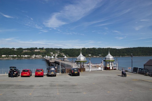
It started to feel like it had been a long walk and I was rather glad to get back to the coast and enter Beaumaris which was busy with tourists crabbing off the pier. wcp-bangor-7wcp-talybont-to-beaumaris

Wales Coast Path: Prestatyn to Colwyn Bay

WCP-17Wednesday, 29th October 2014 – 16.3 miles

A cool but sunny mid-week walk in October half-term. We parked at Barkby Beach, near Pontins, where the ticket machines were out of order, as they had been at the beginning of summer. The walk today was all tarmac or pavement, right along the promenade or embankment.

Embankment near Prestatyn

Embankment near Prestatyn

There were quite a number of people around – dog walkers, cyclists, a few families – as we walked along the embankment with a footpath and cycle path. We passed the start or end of the Offa’s Dyke Path, with this rather nice sculpture, which hadn’t been there all those years ago when we were last in Prestatyn to start that walk!

Offa's Dyke start point

Offa’s Dyke start point

A short walk past a golf course, with caravans in the distance brought us to Rhyl Promenade. Rhyl is looking very run down. Even at half-term, with a good number of visitors about, many amusement arcades and cafes were shut. The Sun Centre closed down earlier this year, but we could still look in through the window. It doesn’t look any different than it did 20 odd years ago! We could also have booked tickets to see Ruth Madoc or Sue Pollard in a choice of panto … we kept walking!

Rhyl Sun Centre

Rhyl Sun Centre

WCP-3

At the far end of town is a new bridge across the harbour, only opened recently to accommodate the Coast Path and cycle route. The sculptures are of famous people from Rhyl …(I can name three famous Belgians!)

WCP-9

Pont y Ddraig

WCP-8We had lunch on a bench overlooking the harbour which was quite pleasant although the sun went in and it got a bit chilly. We took a short detour round the headland to see the view, then continued on a tarmac path past endless caravan parks. Some did at least have grass and some space between caravans, but I do not see the attraction at all.WCP-11 WCP-10A chatty man caught up with us and talked for a while about women’s rugby and maths! We left him at Abergele rail station with the intention of returning by train. However, it had only just gone 2 o’clock so we decided to carry on to Colwyn Bay.WCP-12Past Abergele, the path runs virtually alongside the A55, which is a familiar route. It was rather interesting to walk and see it from a different perspective. Sometimes we were level with the road; other times we dropped down, but could still hear traffic noise. Apart from that, it had a pleasant feel to it, with bushes alongside the path and the sea on the other side. We were interested to see a flock of gulls floating near a set of posts as if they were waiting in turn for the tide to go out so they could sit on the posts as they were uncovered. There were quite a number of cormorants on the posts too. WCP-14 WCP-13Llandulas was a nice spot with an inlet nestled under the dual carriageway. If there had been a station here, that would have been ideal. Instead it became a bit of a slog into Colwyn Bay. However, we did get a closer look at the jetty that takes stone from the quarry. There were people on it so it still is functional.

Jetty near quarry

Jetty near quarry

The path turned into promenade. On our map printed out from the Wales Coast Path website, this is marked as closed with an alternative inland route shown. However, it was all open. I wonder if the promenade had been repaired after last winter’s storms? Also there is a rather swish new marina building, so that could have necessitated some closures, I suppose. We walked up to the pier, arriving just before dusk, with lovely evening light across the bay. The pier is closed and nearly derelict (but looks like an interesting photographic subject!).

WCP-18

Victoria Pier, Colwyn Bay

We turned off then, to the station, just a few hundred yards away. It was a pity that it was too dark on the way back to look out at the way we had come! We were both pretty tired – possibly because it was pretty level and repetitive walking. At least we’ve made it past all those caravans!!

WCP - Prestatyn to Colwyn Bay 16,3 miles